


Center Precinct, Cass County, Nebraska
About
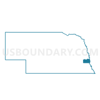
Outline

Summary
| Unique Area Identifier | 612525 |
| Name | Center Precinct |
| County | Cass County |
| State | Nebraska |
| Area (square miles) | 35.96 |
| Land Area (square miles) | 35.91 |
| Water Area (square miles) | 0.05 |
| % of Land Area | 99.87 |
| % of Water Area | 0.13 |
| Latitude of the Internal Point | 40.91747020 |
| Longtitude of the Internal Point | -96.18237370 |
Maps


Graphs
Select a template below for downloading or customizing gragh for Center Precinct, Cass County, Nebraska


Neighbors
Neighoring Voting District (by Name) Neighboring Voting District on the Map
- Avoca Precinct, Cass County, NE
- East Louisville Precinct, Cass County, NE
- Eight Mile Grove Precinct, Cass County, NE
- Elmwood Precinct, Cass County, NE
- Mount Pleasant Precinct, Cass County, NE
- South Bend Precinct, Cass County, NE
- Stove Creek Precinct, Cass County, NE
- Weeping Water 1st Ward, Cass County, NE
- Weeping Water 2nd Ward, Cass County, NE
- West Louisville Precinct, Cass County, NE
Top 10 Neighboring County Subdivision (by Population) Neighboring County Subdivision on the Map
- Louisville precinct, Cass County, NE (1,818)
- Weeping Water city, Cass County, NE (1,050)
- Stove Creek precinct, Cass County, NE (992)
- Eight Mile Grove precinct, Cass County, NE (881)
- South Bend precinct, Cass County, NE (825)
- Elmwood precinct, Cass County, NE (618)
- Avoca precinct, Cass County, NE (596)
- Center precinct, Cass County, NE (527)
- Mount Pleasant precinct, Cass County, NE (238)
- Weeping Water precinct, Cass County, NE (137)
Top 10 Neighboring Place (by Population) Neighboring Place on the Map
Top 10 Neighboring Unified School District (by Population) Neighboring Unified School District on the Map
- Louisville Public Schools, NE (2,995)
- Elmwood-Murdock Public Schools, NE (2,030)
- Weeping Water Public Schools, NE (1,873)
Top 10 Neighboring State Legislative District Upper Chamber (by Population) Neighboring State Legislative District Upper Chamber on the Map
Top 10 Neighboring 111th Congressional District (by Population) Neighboring 111th Congressional District on the Map
Top 10 Neighboring Census Tract (by Population) Neighboring Census Tract on the Map
- Census Tract 9659, Cass County, NE (4,998)
- Census Tract 9657, Cass County, NE (4,778)
- Census Tract 9658, Cass County, NE (2,953)